• <menu id="888u4"><menu id="888u4"></menu></menu>
    • English
    • ???????
    • 中文
    • Fran?ais
    • Русский
    • Espa?ol

    You are here

    Decoding water

    Advanced tools for understanding water resources

    Thomas Perrouy

    A recent IAEA analysis showed that many lakes around the world are unable to compensate for evaporation and are at risk of disappearing over time.? (Photo: Y. Vystavna/IAEA)

    From glacial melt to precipitation patterns and evaporation rates, IAEA isotope hydrologists are collecting, analysing and sharing data to better understand the sources, history and movement of water. New tools and methods allow researchers to analyse water data more precisely than ever, providing critical information for effective water resource management, climate modelling and environmental policymaking.

    “Water data are the backbone of smart policy and informed investments,” said Celeste Saulo, Secretary-General of the World Meteorological Organization. “Without data we are blind. Early warning systems for floods and droughts as well as the design of water infrastructure such as reservoirs, irrigation schemes and drainage systems depend on data. Isotope hydrology adds a unique lens — tracing water sources and flow paths to help us manage shared water resources sustainably.”

    Artificial intelligence

    As global water data networks expand, isotope hydrology is rapidly advancing into the realm of big data. Artificial intelligence (AI) and machine learning models are revealing new insights in water research, improving predictions and filling data gaps.

    An IAEA study that used AI to analyse isotopic data from 1257 lakes in 91 countries revealed that about 20% of their water inflow is lost to evaporation, and in about 10% of cases, the lakes show extreme evaporation losses of more than 40% of total inflow. This means that many lakes cannot compensate for evaporation, which puts them at risk of disappearing over time. “We used artificial intelligence to determine the main evaporation drivers,” said Yuliya Vystavna, an IAEA isotope hydrologist and the study’s first author. “Depending on climate type — tropical, arid, temperate, continental or cold — evaporation is driven by different factors.” The study used AI models to determine which lakes were at greatest risk of disappearing.

    Another IAEA study used machine learning models to identify factors influencing water dynamics and estimate the ‘young water fraction’ — water less than three months old — in 45 river basins around the world. The young water fraction reflects how water is stored and released in the environment, revealing patterns of retention and flow. This helps to increase understanding of how rivers react to weather and land changes, enabling communities to better prepare for floods and droughts and manage their water resources more effectively. “By understanding these dynamics, we can better adapt to the challenges posed by a changing climate and evolving land use patterns, ensuring that rivers continue to provide their essential services to ecosystems and human societies,” said Tzanka Kokalova-Wheldon, Director of the IAEA Division of Physical and Chemical Sciences.

    Experts believe that using AI and machine learning to analyse water data has the potential to significantly improve decision-making processes for sustainable water management. To advance this effort, the IAEA, the United Nations Educational, Scientific and Cultural Organization and the International Centre for Theoretical Physics recently developed a framework for integrating AI with hydrological and isotopic data.

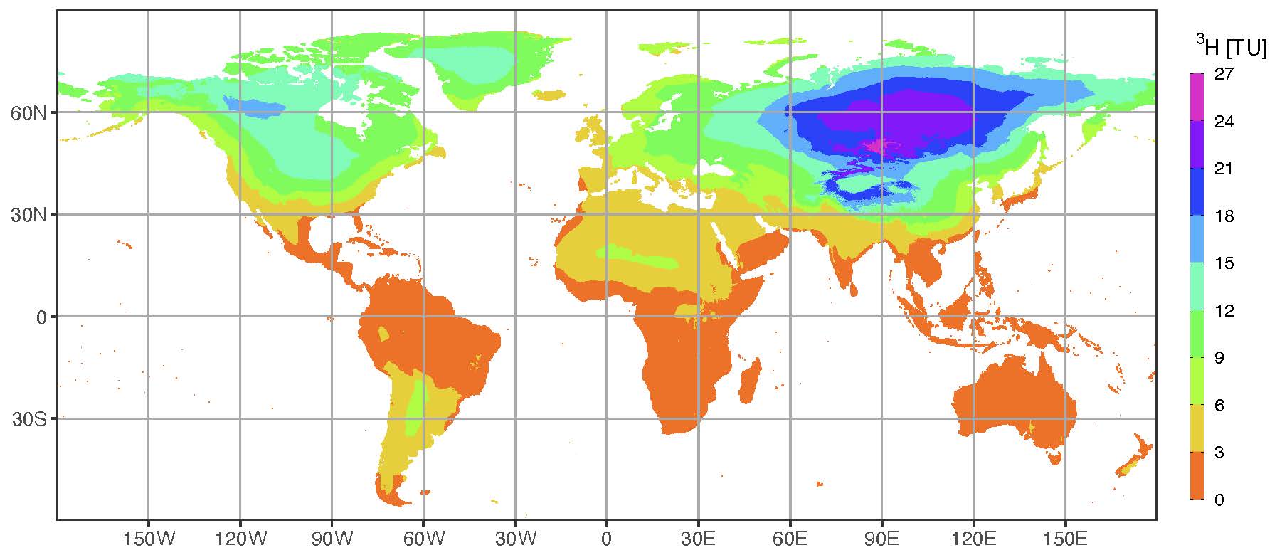
    Contemporary tritium levels in precipitation.? TU denotes tritium activity expressed in tritium units.? (Chart: IAEA)

    High resolution tritium mapping

    Tritium, a naturally occurring radioactive isotope of hydrogen that is present in water and has a half-life of about 12.3 years, is valuable for identifying recently replenished groundwater and assessing its vulnerability to pollution.?By mapping where this trackable form of hydrogen appears in rain and snow, researchers can gain insight into recent water movements and sources. Using data collected over the last decade, the IAEA has developed maps of tritium distribution in precipitation to optimize sampling, identify atmospheric data gaps and support research on aquifer vulnerability.

    Scientists use the maps to compare tritium levels in precipitation and groundwater to understand how quickly precipitation reaches and interacts with aquifers. When groundwater tritium closely matches rainfall tritium, this may signal rapid recharge, meaning that the aquifer is well supplied but also vulnerable to pollution, since pollutants can easily follow the same path. When groundwater contains much less tritium than local rainfall, this may indicate that the water has been safely stored underground and protected from contamination for decades or longer.

    Nitrous oxide laser spectrometry

    Nitrous oxide laser spectrometry is a new technique that provides highly precise measurements of isotopes related to nitrogen cycling (the movement of nitrogen between air, soil, water and organisms), which can be used to trace pollution sources. Because different nitrogen sources (such as the burning of fossil fuels, agricultural emissions and natural processes) have distinct isotopic signatures, scientists can identify and differentiate between human-caused and natural contamination sources. In India, for instance, where fertilizer use has tripled in 30 years, IAEA scientists used the technique to study agriculture’s impact on water systems. Their findings showed that nitrate pollution spikes during the monsoon season when heavy rains wash fertilizers into rivers and lakes, worsening water quality. By tracking isotopes, scientists can pinpoint the sources of this pollution, which may encourage farmers and governments to adopt cleaner practices to improve both water and air quality.?

    As technological capabilities and data collection methods continue to advance, the IAEA is proactively exploring new tools and approaches for water data analysis to support sustainable water management strategies. “By combining cutting-edge technology with decades of water data collected across the globe, we’re not just studying water, we’re empowering countries to make informed decisions about their most precious resource,” said Stefan Terzer-Wassmuth, an IAEA geospatial data expert.

    September, 2025
    Vol. 66-3

    Stay in touch

    Newsletter

    午夜爱爱爱爱爽爽爽视频网站